

Is red light at night best?
Dag Pike considers the age-old adage that using red light preserves your night vision
You don't need complicated maths or even a sextant to enjoy the night sky and use it for navigation, says William Thomson
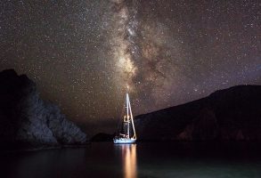
Understanding the night sky
One of my most prized possessions is a book, The History of Seafaring, Navigating the World’s Oceans, by the American sailor Donald S. Johnson.
A treasure trove of priceless knowledge, the story shares our progression in wayfinding since humans first clambered into hollowed-out tree trunks thousands of years ago, and it has taught me that although celestial navigation is ancient, it is also timeless and equally practical today as it was in the days of Captain Cook.
While you could argue that universal access to global positioning satellites, atomic clocks and precision compasses has made celestial navigation irrelevant, another school of thought says there has never been a better time to learn astro-navigation, because we can constantly check our results.
And by no longer needing to rely on time consuming methods like a noon sight to calculate our position, we can disregard antiquated techniques and develop a new system that works in symbiosis with modern technology, enriching our experiences.
The purpose of this series is to explore how, sharing the techniques I’ve tested frequently on passages with my partner Naomi and our children Ottilie and Arva.

Twilight is the ideal time to look for stars as the horizon is still visible and only the brightest stars appear at first
It fills me with a sense of wonder to think of how effectively ancient seafarers could navigate by the stars, especially considering they were working to a flawed system of the universe; geocentrism.
Until just three hundred years ago, the prevailing thinking was that the earth sits motionlessly at the centre of the universe while all the stars and planets orbit around us.
It was not until Nicolaus Copernicus introduced his heliocentric model in the 16th century that the consensus started to change – but it took a long time to gather momentum, amid fierce opposition from the church.
In 1615, Galileo was even investigated by the Roman Inquisition for supporting Copernicus, and found guilty of heresy.
According to the church, heliocentrism was ‘foolish and absurd in philosophy, and formally heretical since it explicitly contradicts in many places the holy scripture’.
Galileo was put under house arrest for the rest of his life and his work was locked away so as to not inspire others.
We now know that Galileo was correct, and that once a year the earth orbits around the sun, 100 million miles away.
The reason we have seasons is because the earth is tilted at 23.5º; at the June solstice, the North Pole is leaning towards the sun and at the December solstice it is facing away from the sun.
This has a profound effect on navigation; at the June Solstice the sun rises and sets to the north of east and west, and culminates (reaches its highest point in the sky) 47º higher above the horizon than at the December solstice, when it rises and sets to the south of east and west.
While all this is happening, the moon is also orbiting the earth once a month, 250,000 miles away.
As many sailors know, the position of the moon in relation to the sun and earth determines the strength of tides – but what is lesser known is that the moon’s phase has a direct connection to what time it rises, culminates and sets (the first quarter rises around mid-day while the third quarter rises around mid-night).
Then we have the planets that seem to disappear at random; this happens when they move behind the sun, a duration that depends on the distance and speed of their orbit.
The furthest planet from us, Pluto, is 2.5 billion miles away and takes 248 earth years to make a single orbit.
Beyond that, we leave the solar system and enter the realm of stars, so far away that they are measured in light years instead of miles.
While an understanding of these true workings of the universe is of great use to a yachtsman, the heliocentric model makes elements of astro-navigation incredibly complex.
To make life easier, we use a hybrid between geocentrism and heliocentrism; the celestial sphere.
In this imaginary system, the world is at the centre of the universe and it spins on its axis once a day.
Projected out from our watery world is the perfectly round celestial sphere, with its poles and equator in direct alignment with ours.
Continues below…

Dag Pike considers the age-old adage that using red light preserves your night vision

Navigation using digital or paper charts is key to good seamanship, but understanding the seven basic types of coastline and…

Cruising after dark doesn't need to be stressful. Toby Heppell shares his tops tips for night sailing
Every star, regardless of how far away it is in reality, has a fixed position on this sphere, like a jewel embedded in a glass orb.
Although there are thousands of stars in the night sky, 58 are officially used for navigation and each one can be found by intersecting two coordinates; declination (Dec.) and sidereal hour angle (S.H.A).
Declination is the celestial equivalent of latitude, measuring the angular distance up to 90° north or south of the equator; this affects how high a star climbs in the night sky.

In astro-navigation, the sun, moon, planets and stars are all placed onto the shell of the celestial sphere and their position can be founded by intersecting declination (latitude) and S.H.A (longitude)
To bisect this, sidereal hour angle is ‘celestial’ longitude and affects the time a star rises and sets each month.
By knowing a star’s declination and sidereal hour angle, you can do incredible things.
You can work out which way is north, south, east and west; you can tell the time and measure distance travelled.

William Thomson is author of The Book of Tides and Tides and the Ocean, creator of TidalCompass and sails a Prout catamaran with his young family
You can even pinpoint your latitude and longitude.
While these abilities are often perceived as a black art beyond most of our mathematical abilities, many of the techniques are actually straightforward once you are familiar with the celestial sphere.
We will start with those.
Polynesian navigators knew, for example, the bearings that specific stars would rise and set, so had a natural compass laid out before them every night.
They were aware that if a star’s declination is the same as your latitude, it culminates directly overhead.
With this knowledge they would navigate over 1,000 miles, with no charts or compasses, from Tahiti to Hawaii (Lat. 19N), sailing north until Arcturus (Dec. 19N) was overhead, then turning due west and sailing down the latitude.
On the return journey back to Tahiti (Lat. 17S), they would use the same technique with Sirius (Dec. 17S).
Closer to home, this strategy can easily be applied in European waters using stars with a northerly declination, which we will test in this series.
Although few of us will ever need to rely entirely on these skills to navigate, there is a pleasure in knowing that we could, if needed.
There is also a soulful element; we do not go sailing to stare at a computer screen.
Celestial navigation helps us shift our attention from screen to the night sky, and because the system is knowledge-based it is weightless, waterproof, and does not use up any precious wattage.
It does get a little dusty if unused, so the idea of this series is to keep our skills polished by getting out and putting theory to practice.
Declination: The angular distance of an object north or south of the celestial equator
Sidereal Hour Angle: The angular distance of an object westwards along the celestial equator
Culmination: The moment a star is positioned highest in the sky, happening when a celestial object transits your nearest meridian
Zenith: A point on the celestial sphere directly overhead an observer’s position
Local Meridian: A semi-circle on the sphere between the poles
Ecliptic: The path of the sun around the celestial sphere once a year
As anyone who has tried celestial navigation will know, the maths can be tricky.

The Star Compass aims to help yo see where a star will appear, anywhere in the world
To make life easier, William has designed a Star Compass that computes this information.
Download and print free at www.tidalcompass.com/star-calculator
Enjoyed reading this?
A subscription to Yachting Monthly magazine costs around 40% less than the cover price.
Print and digital editions are available through Magazines Direct – where you can also find the latest deals.
YM is packed with information to help you get the most from your time on the water.
Follow us on Facebook, Twitter and Instagram.
The post Celestial navigation: understanding the night sky appeared first on Yachting Monthly.