

On any round-the-world cruise by the sunny route, there is the dilemma of how to cross the Indian Ocean. For…
Southern hemisphere cyclones: Everything you need to know
Meteorologist Chris Tibbs explains how Southern hemisphere cyclone systems develop and what sailors need to know about them
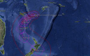
Although New Zealand is not in the tropical cyclone (hurricane) belt, the remains of Tropical Cyclone Gita hit the west coast of both the north and south islands in late February 2018, bringing high winds and storm surge.
As a Category 4 cyclone Gita had already devastated Tonga as the worst storm since modern records began, flattening the 100-year-old Parliament building, among many others. It then continued across the Pacific, missing the more populated islands before curving south then east towards New Zealand.
This does sometimes happen – after we had lost our rig on Concert in the 1996/97 BT Global Challenge we made our way to the Chatham Islands, arriving at the same time as the remains of a tropical storm. With 60 knots through the harbour it was not quite the port of refuge we had hoped for!
Head for Auckland
With Auckland at 37°S, New Zealand is south of the hurricane belt making it an ideal cruising destination in its own right, and also a place to sit out the cyclone season during the southern hemisphere summer. Therefore a significant number of yachts head to New Zealand at the end of the tropical Pacific sailing season, returning at the start of the next one.
This can be a tough passage as at the end of the South Pacific winter depressions frequently still rattle through the Southern Ocean, sending cold fronts across New Zealand and pushing further north. The tropical cyclone season officially starts at the beginning of November (finishing at the end of April) and insurance companies require yachts to be well south by then, or cover will be reduced.
Article continues below…


Jet stream: Everything you need to know about its effect on sailing
What is the jet stream? The jet stream is a ‘river’ of strong wind high in the atmosphere which is…
We therefore sail south before the start of the cyclone season while avoiding the last of the winter gales. Although Auckland is a similar distance south of the equator as the Algarve is north, the cold Southern Ocean is not far away and with large temperature contrasts the weather can change rapidly. It’s around 1,100 miles from Fiji to Auckland and a couple of hundred fewer from New Caledonia, requiring a weather window of a week or more to make the passage.
This makes it quite tricky as there is often a 6-9 day pattern formed of cold fronts, followed by a ridge of high pressure before this is disturbed by the next front. With passage times similar to this cycle, choosing the best departure time to avoid arriving at the same time as an active cold front is important.
The ‘normal’ pattern of high pressure between New Zealand and the tropical Pacific islands means starting the passage in mainly easterly trade winds, but close to New Zealand the predominant wind direction is south-westerly, as it is on the south side of the high pressure.
If all were static it would be a relatively simple passage: let the tradewinds take you to the west of the direct route then the westerlies will bring you east again. However, active cold fronts will come through strongly swinging the wind more to the south.
These are the same cold fronts as the ones bringing ‘southerly busters’ in Australia – just a little further north and generally not quite so aggressive. Starting from New Caledonia, the distance is shorter but you are significantly further east than from Fiji. The passage to New Zealand has a reputation for being a tough one, and timing is everything. Although the pattern may average out at 6-9 days, nothing in the weather is that consistent.
Easier return
The return from New Zealand to the tropical Pacific is generally easier, getting east in the westerlies before tracking north into the trade winds and the tropics. It’s also considered safer as the worst and most changeable weather is likely at the start.
However this is not always the case: as the UK has the Fastnet 79 disaster and Australia the 1998 Sydney Hobart, New Zealand has the Queen’s Birthday storm of June 1994.
A tropical depression quickly formed between Vanuatu and Fiji, and as this low deepened and moved south out of the tropics it entrained cold air, causing the low to rapidly deepen. ‘Explosive cyclogenesis’ is the technical term, although these are sometimes called meteorological bombs when the barometer drops more than 14mb in 24 hours.
In 1994 this generated winds in excess of 50 knots and a swell of 10-15m. This was the height of the season for cruisers heading to the tropical Pacific and whilst 21 people were rescued, three lives and seven boats were lost. It was not a tropical cyclone but still a nasty storm in an area where we expect conditions to be benign.
 About the author
Chris Tibbs is a meteorologist and weather router, as well as a professional sailor and navigator, forecasting for Olympic teams and the ARC rally.
First published in the May 2018 edition of Yachting World.
The post Southern hemisphere cyclones: Everything you need to know appeared first on Yachting World.